This is probably the most spectacular short trip in Africa I have ever taken. So much to write about. So I've broken the blog about this trip into two parts, the first of which is about NIGER, and this second part is about MALI, with its interesting Dogon culture, and of course, Timbuktu!
This marvelous travel program sponsored by the Harvard Museum of
Natural History was one of the best trips of my life! It took place
in 2002, from February 8 through March 1, and was outfitted by Cheri Briggs of
ExploreAfrica. Cheri and her organization are hands-down one of the
best groups to travel with; they have incredible connections and deep knowledge
of the continent, top-to-bottom.
DAY ONE (February 20, 2002).
Our short two
hour flight from Niamey in Niger, on Royal Air Maroc, was one of those classic
adventure travel early morning flights, so we arrived in Bamako at 7:55 a.m.
and met our local guide, Ballo, who was born and raised in Dia, Mopti on the
outskirts of the Timbuktu desert. We
were transferred to Hotel Salam, said to be the nicest hotel in Bamako. We exchanged our dollars into the local
currency, CFA, at the rate of 650 CFS per $1 USD. Hopefully in the intervening 19 years between
this trip and my finally writing this blogpost, Bamako has revitalized.
DAY TWO:
We left Bamako to make the approximately four hour drive
to Segu, the ancient capital of the Bambara kingdom. Along the way, we visited a Bambara
village. There were plenty of roadside
attractions:
A butcher shop sports a Coca-Cola
umbrella as an attraction.

An overworked donkey carries 6 people.

A bike and moped repair entrepreneur
on the side of the road.


Here is a local petrol station.

Over vans were crowded, but… we could
have been traveling like this.

The day before the festival, all the
kids get their haircuts and get ready.

Animals work very hard here.

Millet for market, hay for animals…

A village granary

On the way to the market…

At last we reached Segu, a large town
located 140 miles east of Bamako on the South bank of the Niger river. (do the math:
140 miles in 4 hours = and average pace of 35 miles an hour.)
A market lady selling fresh fruit and
vegetables outside our Hotel L’Auberge in Segu.

In the background of this basket-seller (the lad wearing the “World’s Best Mom” tee-shirt; we do see a lot of secondhand clothes in Africa everywhere) are red-mud houses that are unique to this area. Founded in 1852, Segu is now one of the main industrial and commercial centers of Mali.

We visited a local school before
overnighting in Segu.


DAY THREE:
It’s a 6 hour
drive to Mopti. Mopti is called “the
Malian Venice” and is located at the junction of the Bani and Niger
rivers. It is completely surrounded by
water. It is the starting point of many tour, as it is a commercial crossroads
and became the economic capital of Mali as commerce on the Niger River
increased during the colonial period and its location gave it an advantage over
Djenne and Timbuktu. “As commerce and
tourism grow on the Niger, so grows Mopti,” says our handout. “This is a town
of hopes, dreams, greed, success, and failure.”
In 2002, the town had approximately 100,000 inhabitants, a large market,
a beautiful mosque and a vibrant port.
We boarded a pirogue for a cruise of
the Niger and Bani rivers and a brief look at the fisherman villages of the
Bozo people.

On the banks of the Niger River in Mopti, women do
laundry.


The headman in a nearby village is
proud of his granddaughter; there are many babies in Mali.

Preparing millet for the evening meal
is a never-ending job of the women.
Pounded by mortar into big wooden pestles: it’s hard work.

The local mosque in this village has
ostrich eggs mounted on the top: a
sign of good luck.

The boats on the Bani River show that
it’s a thriving commercial area.


Many boats are decorated, and many
have good-luck signs on them.


We go to a Bozo fisherman’s village on
an island in the Bani. From an early
age, kids learn how to balance loads on their heads.


Baby transport! (this, in my opinion, is my National Geo-worthy photo from Mali)

A fisherwoman still needs to pound
millet for the evening meal.

In this village, the mosque is made
from mud bricks.

There is a Fulani settlement at one
end of the island. (and after this trip, I own a Fulani hat...)


DAY FOUR:
We drive to Djenne, which includes putting the vans on a ferry to cross the Niger River. Djenne is called the “Jewel of the Niger Valley”, and has a famous mosque which is one of the greatest mud-made monuments in the world. It’s a festival day, and families are hurrying to the service for this major festival day – the Festival of Ibraham.

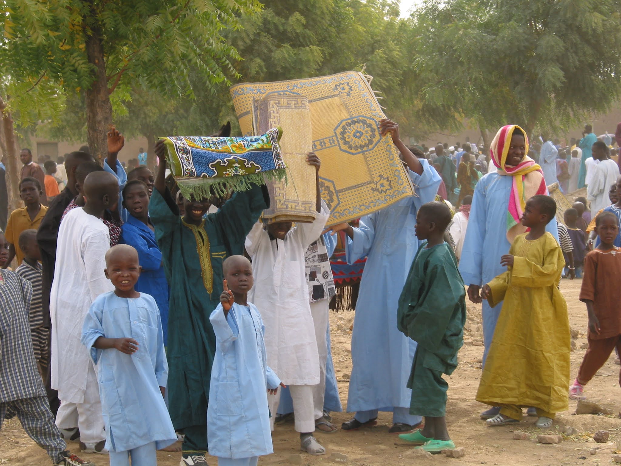
A sheep is slaughtered for a family’s
festival meal – right in the street.
Ugh.

It’s an interesting town to walk
around – decorated wagons, doors, windows.


We visited the 250 B.C. archaeological site of Jenne-Jeno.

And we visited a master of mud-cloth, a unique textile art form from Mali, in her home shop.

DAY FIVE:
We drove four hours, mostly on rough
dirt roads toward Sangha. (We were
forewarned that the rooms at the Campement of Sangha Hotel are small and square with fans that do not
help too much with the heat; and toilet facilities are shared. Lights go out at midnight and are turned on
around 5:30 in the morning. So a good
flashlight was necessary! It was a miserable place, and the home of the famous rocking toilet… apparently no
instruction ever occurred on the need to anchor a toilet to the floor of the
stifling toilet room. Imagine the worse
truckstop bathroom you’ve ever been in, and you’ve got it. I know, I know… such
a First World attitude… )
So we are on our way to Dogon country. Sangha is in the heart of Dogon country.
ABOUT THE DOGON Originally, the Dogon people
came from the Mandingue Country and fled to this rocky place to hide themselves
from Islamization several centuries ago.
Protected by the cliffs of Bandiagara, the Dogon people were almost
entirely isolated from the world. They
have a social solidarity based on a complex combination of philosophic and
religious dogmas, the fundamental law being the worship of ancestors. Ritual masks and corpses are kept in the caves. Dogon architecture is unique: there are three
types of villages – the villages of the plateau, the cliff villages, and the
villages of the lowland or plain. Today,
Dogons are Muslims and animists.
The houses in Sangha cling onto the
cliff walls along narrow paths. Sangha
is on the border of the plateau and the plain, but is still considered a
plateau village.

Walking through the village, we see
the Tonguna or “house of elders”, where
men get to rest while the women work.

We saw the sorcerer’s house, adorned
with many magical items.

We climbed the path up to the
circumcision cave.
The walls of the cave area are highly
decorated.

One decoration is a symbol of the
knife used for the circumcision.

Traditionally, a “class" of 70-90
teenage boys is all circumcised at once.
After the ceremony, they boys are introduced to the mysteries of the
clan… the 5 great families (depicted below on the cave wall), etc.

Here is the rock where the circumciser
sits.

There is a space in the cave to keep
the sacred instruments. Here is the
keeper of the instruments. Women are
forbidden to ever see them! (we female
tourists are not considered women… by the way.)


In Sangha village, a carver shows off
his own personal fetish. This protects
him from harm.


There is serious belief in sorcery
here. On the outskirts of Sangha
village, a sorcerer casts his spells. Overnight,
the wind blows and the birds and foxes walk though, determining the answer to
questions posed by the sorcerer (and paid for by his clients).

DAY SIX:
We drive to the cliffside village of Tirelli, in the heart of the Dogon country. At the base of the cliff are the village houses.

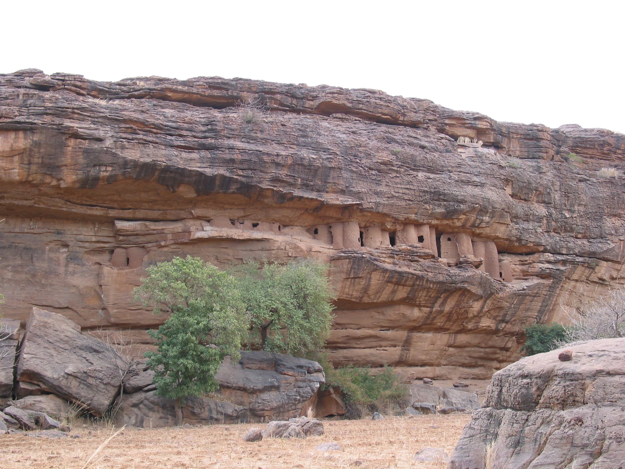
In the escarpment near Bandiagara, before the 14th Century, the Tellem tribe established homes and burial sites in the caves. When the Dogon came to escape from the Muslims, the Tellems disappeared under unknown circumstances.

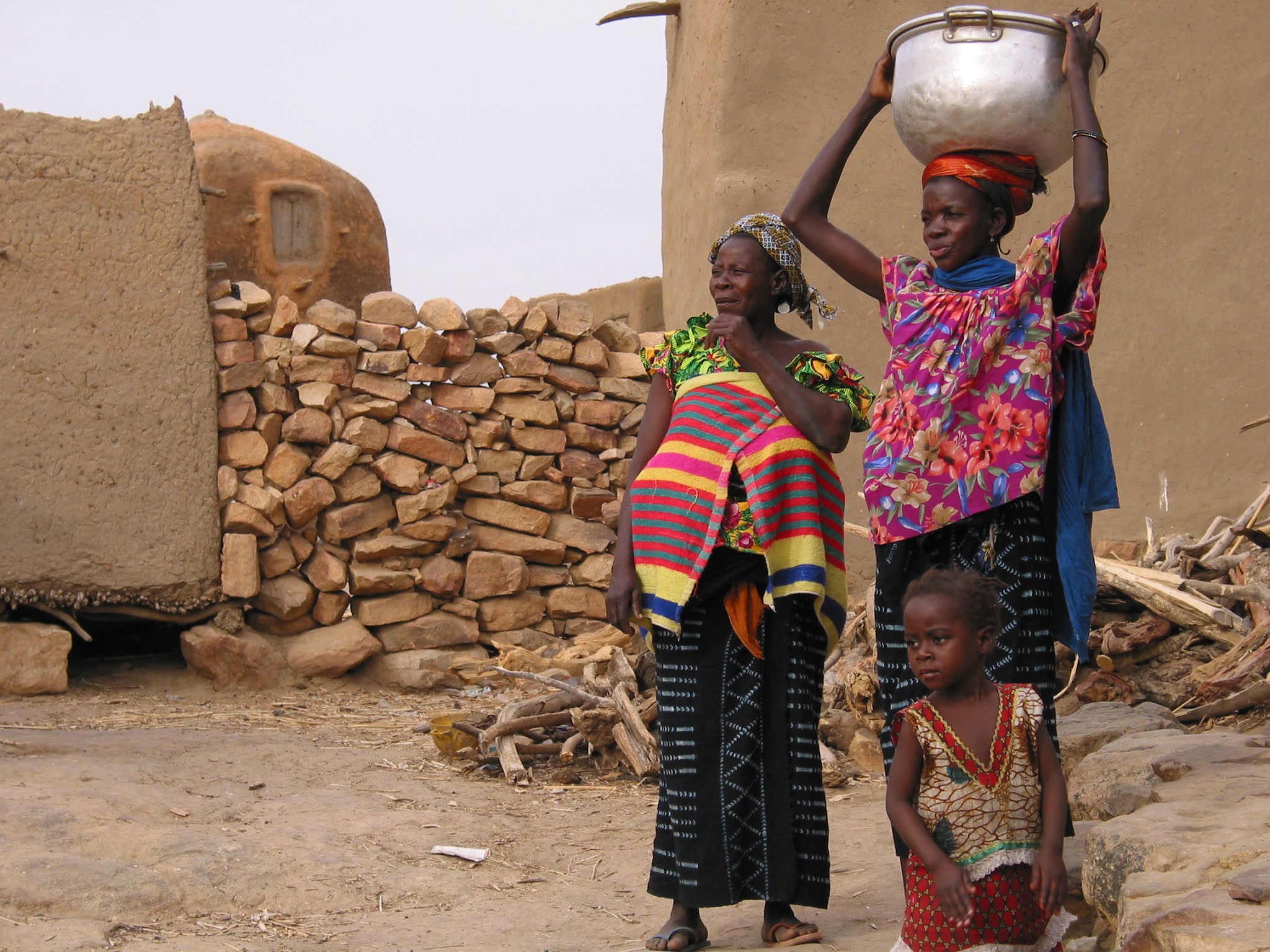
Women walk at least a mile in each
direction to get water and haul it back up the hill, making several journeys
each day!
The Dogon mask dance in Tirelli centers around the “Navel” of the village. It is absolutely wonderful, and everything you'd want to see in a vigorous dance, including walking on stilts. The Dogon costumes for this dance are famous world-around!


(here is a video)
We drive back to Bandiagara to stay at
the wonderful “Cheval Blanc” hotel, aka the Hotel Kambary. It was designed by an architect from Italy,
was run by a Swiss woman, and the dome-shaped brick chalets provide good
respite from the heat. Again, a good flashlight recommended…

DAY SEVEN:
We drive two hours back to Mopti’s
airport and take a one-hour flight to Timbuktu.
We were supposed to stay at the Hotel Colombe there, but a private jet
of around-the-world-traveler types landed, and we were shunted off to
barely-acceptable accommodations.
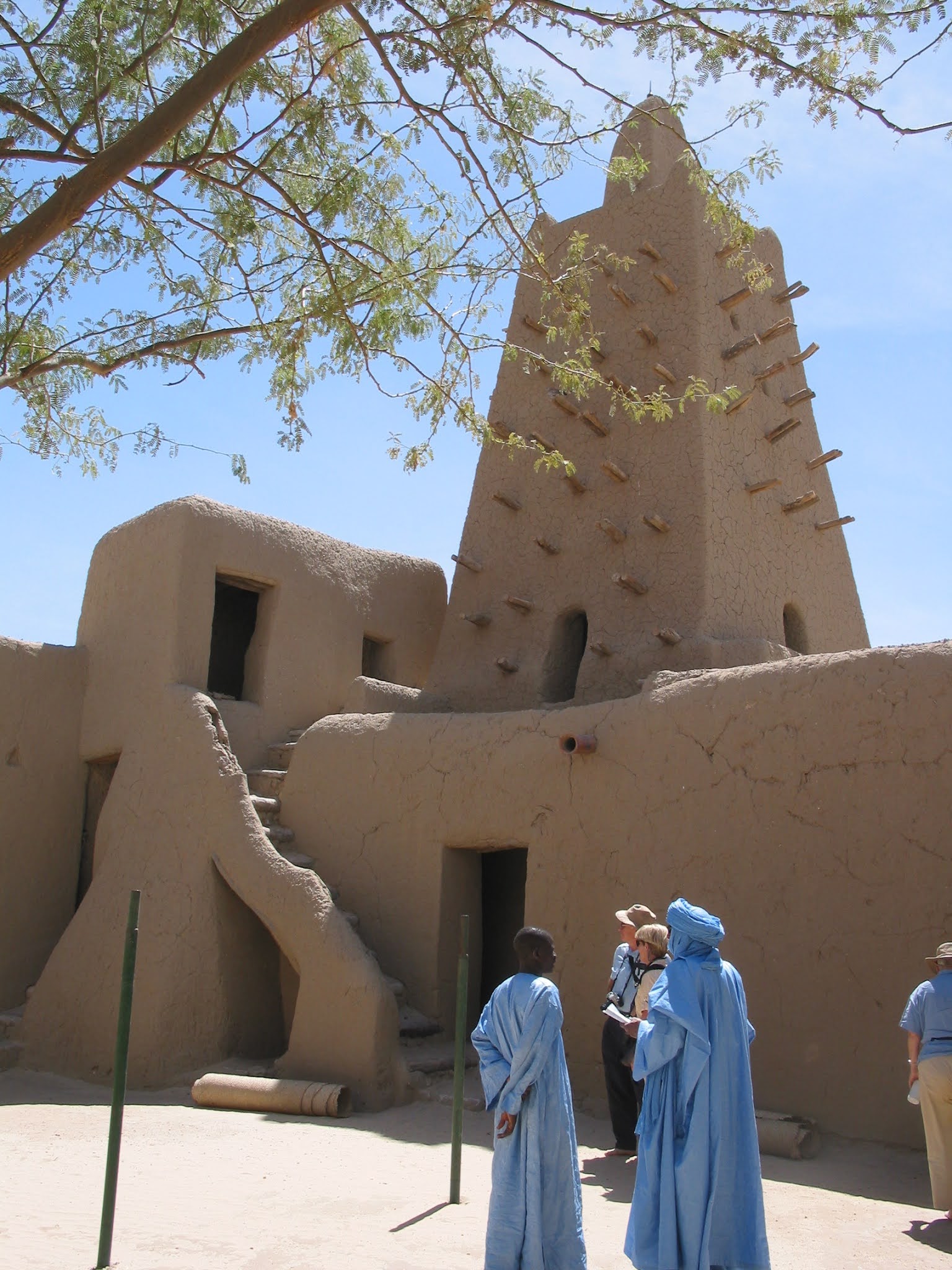
We visited Timbuktu’s main mosque, the
Djingareiber Mosque, and also some houses of European explorers.
Timbuktu (also known as Tombouctou)
was an intellectual capital city and commercial metropolis. Built in the 12th century by
Tuareg nomads around a well, “tim” in Tamashek, which had a watchwoman named
“Buktu”.
A LITTLE MORE BACKGROUND: Not being located near a waterway, Timbuktu
was linked to its harbor by a channel dug by hand. It’s twin sister city,
Djenne, used to send its produce from savanna to the huger river banks for
transport. Timbuktu was also the place
where salt caravans from Taoudenit passed by, overall making it an interesting
ethnic crossroads.
As befits a major commercial and intellectual center, the houses display beautiful touches of design.


But here, as elsewhere, the poorest of the
poor live in a shantytown.

The museum in Timbuktu featured a re-creation
of a nomad camp.


Scenes from the main market in
Timbuktu.


Here is the shop where I bought a BouBou
(blue Tuareg garment) and yards of indigo for a Sheesh. When you come to my house, you’ll see a
mannequin dressed in these genuine pieces, sporting Taureg swords and Gris-Gris
amulets. Although Aghali in Niger
showed me how to wrap a Sheesh, I had to turn to the internet for a
refresher:
https://www.youtube.com/watch?v=zhpRsXd7GJk


The university was once the greatest
center of Islamic learning in the world.

We go into the desert outside of town
to see a Tuareg “sword dance”. Everyone wants to attend!


The henna-ed hands of the
highest-status women.

The women make the music and chant.


As the sun goes down, we have a meal
on colorful rugs laid on the desert floor outside of Timbuktu.


The campfire illuminated a beautiful
sunset over this precious world-heritage town.
DAY EIGHT:
A two hour flight from the Timbuktu
airport takes us back to Bamako.


DAY NINE:
And from Bamako, I got on Air France to
Paris, and then onward to London to visit my sister-in-law Kimbro. I didn’t need a flashlight at her place. Thank you again, Kim, for taking in a dusty
traveler and offering a cup of tea and a biscuit!
~~~~~~~~~~~~~~~~~~~~~~~~~~~~~~~~~~~~~~~~~~~~~~~~~~~~~~~~
I am grateful to
have seen Timbuktu before it was trashed by the radical Islamic militant group Ansar Dines in 2012. It will
never be the same; so many irreplaceable manuscripts were destroyed. But what follows is the kind of news report
that is not all that infrequent from Mali, and it is relatively recent
too. Not exactly something that makes me
want to pack my desert clothes and head to Bamako again:
“Event (April, 2020)
Suspected
Fulani herdsmen attacked several villages in the vicinity of Dogon village of
Tirelli (Mopti region) on Tuesday, April 21, killing at least 12 people.
According to local media reports, scores of herders attacked the area, located
approximately 30 km (18.6 mi) east of Bandiagara, between 16:00 and 21:00
(local time). The herders reportedly stole 500 cattle in their attacks and at
least six other residents of the area have been reported missing. Further intercommunal clashes between the
Fulani and Dogon communities, and other communities, are to be expected in the
Mopti region over the near term.
Advice
The
security environment in Mali remains complex. Professional security advice and
support should be sought prior to travel.
Due
to the underlying terrorist and kidnapping threats prevalent in the country,
all those present in Mali are advised to remain discreet regarding personal
details, particularly information concerning nationality, employment, family,
etc. Individuals are also advised to avoid public events and places frequented
by Westerners, to remain vigilant at all times (especially in local markets,
now used by terrorists as recruitment grounds), and to report any suspicious
objects or behavior to the authorities.”